Manaslu Circuit Trek Route and Map: Complete Stage-by-Stage Guide
July 8, 2026 Lhasso Adventure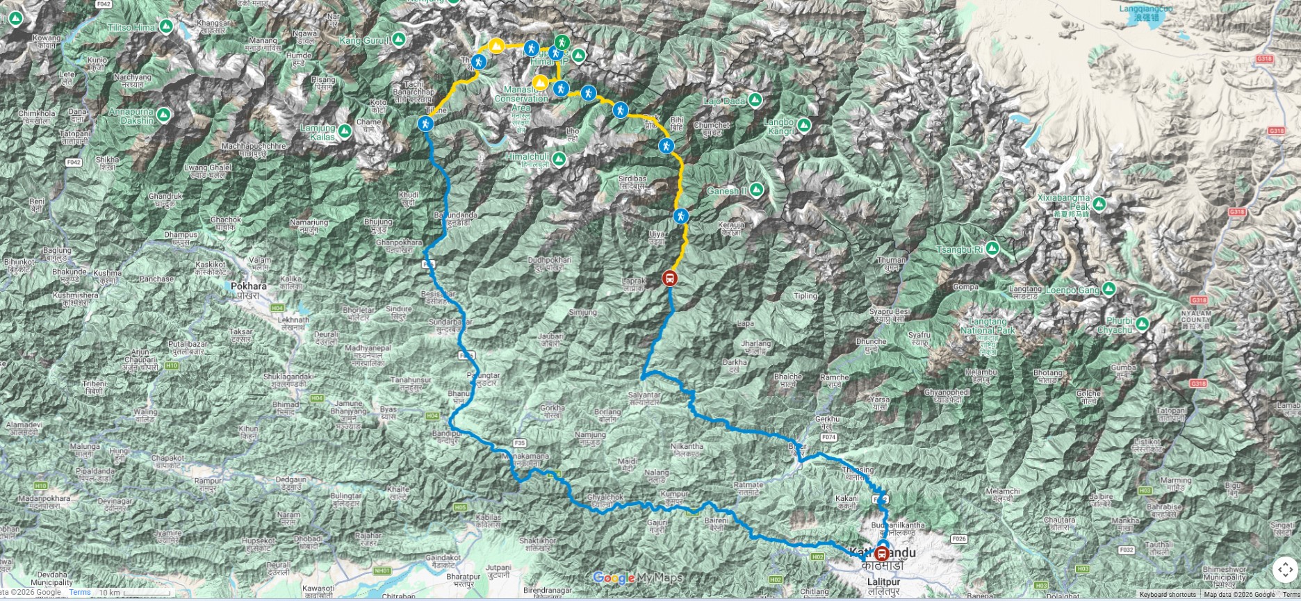
The Manaslu Circuit Trek route is a circular Himalayan trekking path that circles Mount Manaslu (8,163m), the eighth-highest mountain in the world. The trail connects remote valleys, high mountain passes, traditional villages, and diverse ecological zones before descending into the Annapurna region.
The route is considered one of Nepal’s most scenic and culturally rich trekking circuits because it passes through both restricted and conservation areas, offering a gradual transition from low-altitude river valleys to high alpine terrain.
Understanding the full route is essential before trekking because daily walking distance, elevation gain, and acclimatization stages directly influence safety and overall trekking experience.
This guide breaks down the entire Manaslu Circuit Trek route into clear stages, helping trekkers visualize the journey from start to finish.
Where Does the Manaslu Circuit Trek Start and End?
The Manaslu Circuit Trek traditionally starts from Soti Khola or Machha Khola, depending on road conditions and seasonal accessibility.
The trek ends in Dharapani after crossing Larkya La Pass, where the route merges into the Annapurna Conservation Area.
This makes the Manaslu Circuit a complete loop-style Himalayan trek that connects two major trekking regions of Nepal.
The starting and ending points may slightly vary depending on road conditions, but the core trekking route remains consistent.
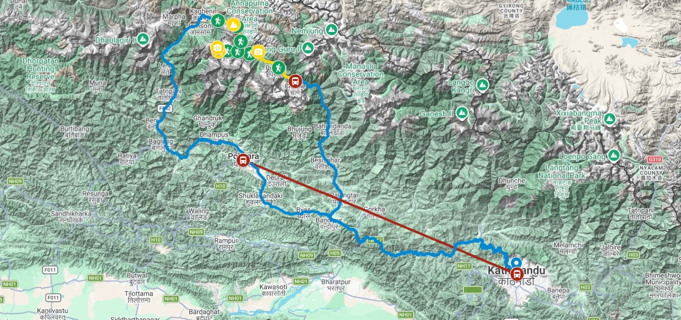
This structure is closely linked with road access conditions between Kathmandu and remote Himalayan villages at the beginning of the trek, which often influence the exact starting point.
Stage 1: Kathmandu to Machha Khola (Drive)
The journey begins with a long overland drive from Kathmandu to Machha Khola, which serves as the official gateway to the Manaslu region.
The drive passes through hilly terrain, riverside roads, and rural settlements before reaching the lower Gorkha region.
Road conditions vary depending on season and weather, and travel time can fluctuate significantly.
This section marks the transition from urban Kathmandu to remote Himalayan landscapes, setting the tone for the trek ahead.
Stage 2: Machha Khola to Jagat
The trekking route officially begins from Machha Khola, following the Budhi Gandaki River valley.
The trail passes through suspension bridges, small villages, and terraced landscapes before reaching Jagat.
Jagat is an important checkpoint village where permit verification begins, especially for restricted area entry.
This section introduces trekkers to the gradual increase in elevation and changing landscape structure of the Manaslu region.
It is also the point where trekking starts feeling more remote and less connected to road infrastructure.
Stage 3: Jagat to Deng
From Jagat, the trail continues deeper into the Manaslu Conservation Area, passing through forested sections and traditional settlements.
The landscape becomes more rugged, and the cultural influence shifts toward Tibetan-influenced mountain communities.
Deng marks a significant transition point where trekkers begin experiencing more isolated terrain and quieter trails.
This stage is important for early acclimatization and steady elevation gain.
It is closely connected with gradual altitude adaptation during multi-day Himalayan trekking routes, which becomes increasingly important beyond this section.
Stage 4: Deng to Namrung
The trail from Deng to Namrung involves steeper ascents and more dramatic mountain scenery.
Villages become more spaced out, and the architecture reflects stronger Tibetan cultural influence.
Namrung is a key overnight stop with better mountain views and improved accommodation compared to lower sections.
This stage marks the transition into higher Himalayan terrain where weather conditions become more noticeable and temperatures begin to drop.
Stage 5: Namrung to Samagaon
This is one of the most visually impressive sections of the Manaslu Circuit Trek route.
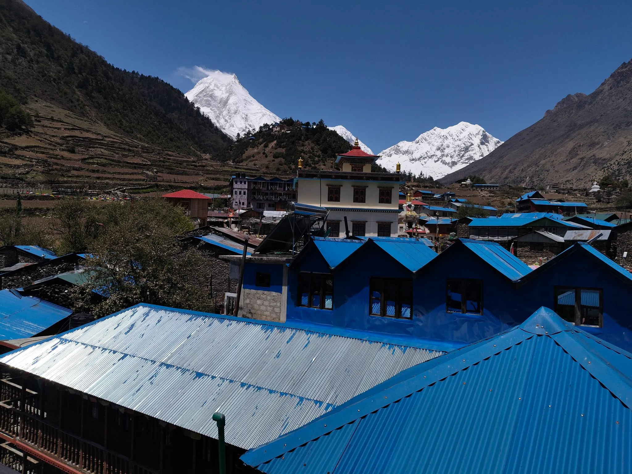
The trail passes through Lho and Shyala villages, offering stunning views of Mount Manaslu and surrounding peaks.
Samagaon is a major acclimatization village and one of the most important stops on the entire route.
Trekkers often spend an extra day here to adjust to altitude before moving toward higher elevations.
This stage plays a crucial role in preparing for the ascent toward Larkya La Pass and is strongly connected to acclimatization strategies in high-altitude Himalayan trekking environments.
Stage 6: Samagaon to Samdo
The trail from Samagaon to Samdo becomes noticeably more barren and alpine in nature.
Vegetation reduces significantly, and the terrain becomes more rugged and exposed.
Samdo is one of the last major settlements before entering the high-pass region of the trek.
This village is located close to the Tibetan border and has a strong cultural influence from cross-border trade and traditions.
Trekkers typically use Samdo as a final preparation stop before heading toward the highest section of the route.
Stage 7: Samdo to Dharamsala (Larkya Phedi)
This section leads to Dharamsala, also known as Larkya Phedi, which serves as the base before crossing Larkya La Pass.
The trail becomes steeper, colder, and more physically demanding.
Accommodation here is basic, and the focus is primarily on rest and preparation for the next day’s pass crossing.
This stage is critical for final altitude adjustment and energy conservation.
It is directly linked to physical demands encountered during long multi-day Himalayan trekking routes at extreme elevation levels.
Samdo to Larkya La Pass Region: Final Approach to the High Himalaya
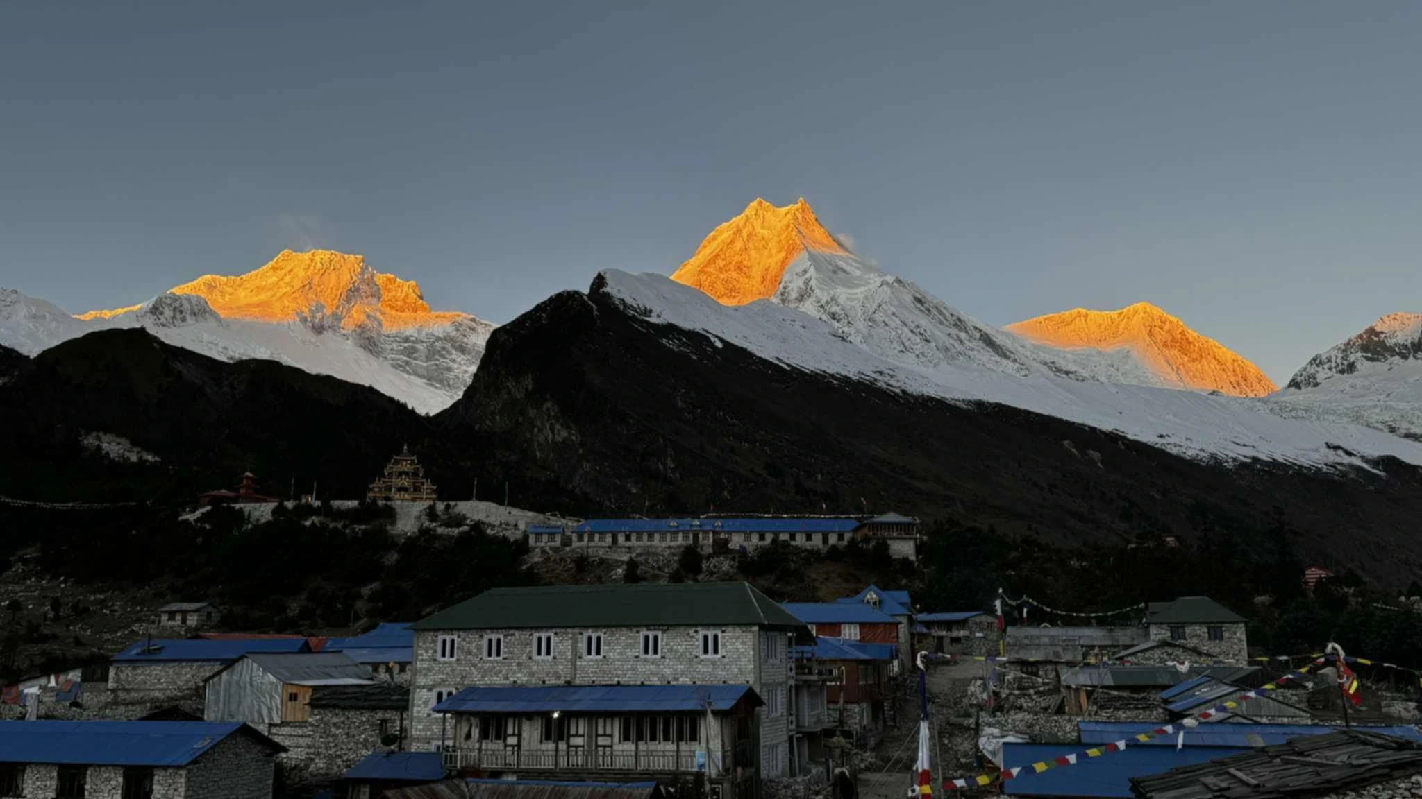
The section from Samdo toward Larkya La Pass is where the Manaslu Circuit Trek begins to feel truly high-altitude. The landscape becomes more alpine, vegetation is minimal, and weather conditions become significantly more unpredictable.
This stretch is not only physically demanding but also mentally important, as trekkers prepare for the highest point of the entire route.
The trail gradually ascends toward Dharamsala (Larkya Phedi), which serves as the final resting point before the pass crossing.
This phase is closely connected to physical demands encountered during long multi-day Himalayan trekking routes at extreme elevation levels, where energy conservation and pacing become critical.
Dharamsala (Larkya Phedi): The Final Preparation Point
Dharamsala, also known as Larkya Phedi, is the last stop before crossing Larkya La Pass. It is a basic accommodation area located in a remote and high-altitude environment.
Facilities here are minimal, with simple lodging and limited services due to the harsh terrain and altitude conditions.
Trekkers usually arrive early to rest and prepare for the early morning ascent toward the pass.
This stop plays a crucial role in acclimatization and route timing, as crossing conditions depend heavily on weather stability and wind patterns.
The overnight stay here is short but strategically important for a safe pass crossing.
Larkya La Pass (5,160m): The Highest Point of the Trek
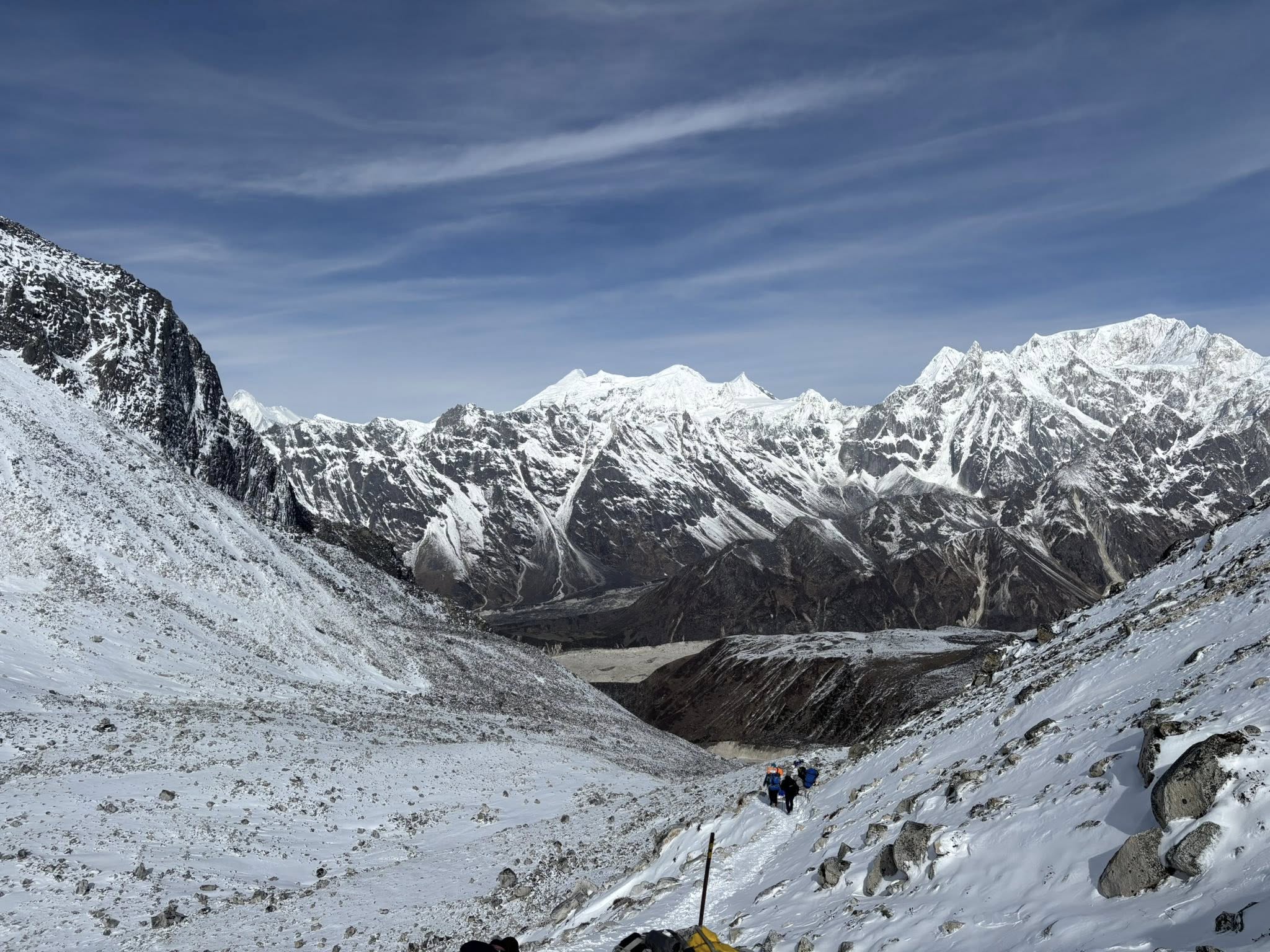
Larkya La Pass is the highest and most challenging section of the Manaslu Circuit Trek route. It stands at approximately 5,160 meters and connects the Manaslu region with the Annapurna Conservation Area.
The ascent begins early in the morning, often before sunrise, to avoid strong winds and unstable weather conditions later in the day.
The trail is steep, rocky, and often covered with snow depending on the season. Physical endurance and steady pacing are essential throughout the climb.
Reaching the top of Larkya La Pass offers panoramic views of Himalayan peaks including Manaslu, Himlung Himal, Cheo Himal, and Annapurna ranges.
The descent from the pass is long and requires careful movement due to loose terrain and fatigue accumulated during the ascent.
This section is directly linked to altitude adaptation strategies in extreme Himalayan environments above 5,000 meters, where oxygen levels are significantly reduced.
Descent from Larkya La to Bimthang
After crossing the pass, the trail descends toward Bimthang, a wide valley surrounded by snow-covered peaks and glacial landscapes.
The descent is long but visually rewarding, offering some of the most dramatic scenery on the entire Manaslu Circuit Trek route.
Bimthang provides a welcome return to slightly lower altitude conditions, allowing trekkers to recover after the demanding pass crossing.
This section marks the transition from the restricted Manaslu region into the Annapurna Conservation Area.
The change in landscape is immediate, with greener valleys and more open terrain replacing the harsh alpine environment.
Bimthang to Dharapani: Exit from the Manaslu Circuit
From Bimthang, the trail continues downhill through forested areas, rivers, and small settlements before reaching Dharapani.
This section is significantly easier compared to earlier stages, but still requires steady pacing due to long descent distances.
Dharapani serves as the official exit point of the Manaslu Circuit Trek, where the route merges with the Annapurna trekking network.
This transition marks the completion of the circular route around Mount Manaslu.
At this stage, trekkers leave the restricted area and re-enter more accessible trekking infrastructure.
Understanding the Manaslu Circuit Trek Map
The Manaslu Circuit Trek map is best understood as a gradual elevation arc rather than a simple point-to-point trail.
The route starts in low-altitude river valleys and steadily climbs through forested hills, alpine villages, and high mountain terrain before reaching Larkya La Pass.
After crossing the pass, the route descends sharply into the Annapurna region, completing the circular structure of the trek.
Key map zones include:
- Lower Valley Zone (Machha Khola to Jagat)
- Mid-Himalayan Village Zone (Deng to Namrung)
- High Acclimatization Zone (Samagaon and Samdo)
- High Pass Zone (Dharamsala to Larkya La Pass)
- Descent Zone (Bimthang to Dharapani)
This zoning helps trekkers understand terrain changes, altitude progression, and daily trekking difficulty.
Elevation Profile of the Manaslu Circuit Trek
The elevation profile of the Manaslu Circuit Trek is one of the most important aspects of route planning.
The trek begins at around 700–900 meters and gradually rises to over 5,000 meters at Larkya La Pass.
The most important acclimatization point is Samagaon, which helps trekkers adjust before entering higher altitude zones.
Elevation gain is not linear, and certain sections involve steep climbs followed by long descents, making energy management essential.
Understanding elevation changes is directly linked to gradual altitude adaptation during multi-day Himalayan trekking routes, especially in high mountain environments.
Route Difficulty Zones Along the Manaslu Circuit
The Manaslu Circuit Trek can be divided into different difficulty zones based on terrain and altitude:
- Lower Zone: Moderate walking on river valleys and gradual ascents
- Mid Zone: Increasing elevation with forested trails and cultural villages
- High Zone: Thin air, steep ascents, and colder conditions
- Pass Zone: Extreme altitude, snow, and high physical demand
- Descent Zone: Long downhill sections requiring knee endurance
Each zone requires different levels of energy management and pacing strategy.
This structured breakdown helps trekkers prepare mentally and physically for each stage of the journey.
How Many Days Does the Manaslu Circuit Route Take?
The full Manaslu Circuit Trek route typically takes 10 to 15 days depending on itinerary design, acclimatization days, and trekking pace.
Shorter itineraries may reduce rest days, while longer itineraries allow better altitude adjustment and more gradual progression.
The total duration is also influenced by weather conditions, group pace, and logistical planning.
Proper pacing is essential for safety, especially when approaching high-altitude sections near Larkya La Pass.
Day-by-Day Route Overview of the Manaslu Circuit Trek
The Manaslu Circuit Trek route is most commonly completed in 12 to 16 days depending on acclimatization, weather conditions, and trekking pace. While the physical trail remains consistent, daily itinerary structure can vary based on safety, altitude adaptation, and group preference.
Understanding the day-by-day flow helps trekkers connect the map with real on-ground movement and prepare mentally for each stage of the journey.
This structure is closely linked with permit duration rules and trekking pace planning, as the number of days spent inside the restricted area directly influences both logistics and cost.
Day 1–2: Kathmandu to Machha Khola and Trek to Jagat
The journey begins with a long drive from Kathmandu to Machha Khola, followed by the first trekking day toward Jagat.
These initial days transition trekkers from urban environments into rural river valley landscapes.
Jagat serves as an important entry checkpoint into regulated trekking zones where permits begin to be verified.
This section helps the body adjust to walking rhythm and prepares trekkers for gradual elevation gain.
Day 3–5: Jagat to Deng and Namrung
From Jagat, the trail gradually climbs through forested hills, suspension bridges, and traditional villages toward Deng and Namrung.
This section introduces more remote terrain and stronger Tibetan cultural influence in architecture and lifestyle.
Elevation gain becomes more noticeable, and trekking begins to feel more physically demanding.
Namrung offers improved views and better acclimatization conditions before entering higher Himalayan zones.
This phase is directly connected to gradual altitude adaptation during multi-day Himalayan trekking routes, where pacing becomes essential for safety.
Day 6–8: Namrung to Samagaon (Acclimatization Zone)
The route from Namrung to Samagaon is one of the most scenic and important sections of the entire trek.
Villages like Lho and Shyala offer clear views of Mount Manaslu and surrounding peaks.
Samagaon is a major acclimatization stop where trekkers typically spend an extra day to adjust to altitude.
Side hikes such as Manaslu Base Camp or Pungen Gompa are often included here for better altitude adaptation.
This section is strongly linked to acclimatization strategies in high-altitude Himalayan trekking environments, which are critical before entering higher zones.
Day 9–10: Samagaon to Samdo (High Alpine Transition)
The trail from Samagaon to Samdo marks a noticeable shift in landscape and altitude.
Vegetation becomes sparse, and the terrain turns more rugged and exposed.
Samdo is one of the last settlements before the high pass region and is located close to the Tibetan border.
This village is often used for short acclimatization hikes and rest before moving toward Dharamsala.
The atmosphere here becomes significantly colder and more remote.
Day 11: Samdo to Dharamsala (Larkya Phedi)
This short but important trekking day leads to Dharamsala, the final base before crossing Larkya La Pass.
The trail becomes steep and physically demanding despite the shorter distance.
Accommodation is basic, and the focus is entirely on rest, hydration, and preparation for the pass crossing.
Trekkers typically arrive early to conserve energy for the early morning ascent.
This section is closely associated with physical demands encountered during long multi-day Himalayan trekking routes at extreme elevation levels.
Day 12: Larkya La Pass Crossing to Bimthang
This is the most challenging and rewarding day of the entire Manaslu Circuit Trek route.
The climb to Larkya La Pass begins before sunrise, with steep ascents and cold, high-altitude conditions.
After reaching the summit at 5,160 meters, trekkers descend toward Bimthang through long and demanding downhill terrain.
This section offers some of the most dramatic mountain views of the entire journey.
It represents the transition from the Manaslu region into the Annapurna Conservation Area.
This stage is directly connected to altitude adaptation strategies in extreme Himalayan environments above 5,000 meters, where endurance and pacing are critical.
Day 13–14: Bimthang to Dharapani and Exit Route
After the pass crossing, the route descends gradually through forests, rivers, and open valleys toward Dharapani.
This section feels significantly easier compared to the high-altitude days but still requires endurance due to long downhill sections.
Dharapani marks the official exit point of the Manaslu Circuit Trek and connects with the Annapurna trekking network.
From here, trekkers typically drive back toward Kathmandu via Besisahar.
This completes the full circular route around Mount Manaslu.
Side Routes and Optional Extensions on the Manaslu Circuit
The Manaslu Circuit Trek also includes several optional side routes that enhance acclimatization and cultural exploration.
These side hikes are not mandatory but are highly recommended for better altitude adjustment and deeper exploration of the region.
Manaslu Base Camp Hike
From Samagaon, trekkers can hike to Manaslu Base Camp, which offers close-up views of Mount Manaslu glacier systems.
This is a challenging day hike that helps with acclimatization before moving toward Samdo and Larkya La Pass.
It is one of the most popular optional extensions on the route.
Pungen Gompa (Pungyen Monastery) Hike
Another important side trip from Samagaon is the hike to Pungen Gompa.
This route offers panoramic views of Manaslu and surrounding peaks along with cultural insight into local monastic life.
The trail is moderately difficult and highly rewarding in terms of scenery and spiritual atmosphere.
Rui La Border Viewpoint (Advanced Extension)
For experienced trekkers with additional time, Rui La offers a viewpoint near the Tibetan border.
This route is less frequently visited and provides a raw, remote Himalayan experience.
It is generally included only in extended itineraries.
Route Variations in the Manaslu Circuit Trek
The Manaslu Circuit Trek route can vary slightly depending on road conditions, weather, and itinerary design.
Some trekkers start from Machha Khola, while others begin from Soti Khola depending on accessibility.
Similarly, the endpoint may shift slightly based on exit road conditions in the Annapurna region.
These variations do not change the core structure of the trek but may affect total duration and daily walking distance.
Route flexibility is an important part of daily trekking route planning across restricted Himalayan villages and conservation zones.
Seasonal Changes in the Manaslu Route
The Manaslu Circuit Trek route remains physically the same throughout the year, but conditions change significantly depending on season.
In spring and autumn, trails are dry and visibility is clear, making navigation easier.
During monsoon, lower sections may experience landslides and muddy conditions.
In winter, high-altitude sections near Larkya La Pass may be affected by snow, requiring careful timing and preparation.
Seasonal awareness is essential for safe navigation and proper itinerary planning.
Conclusion: Understanding the Full Manaslu Circuit Trek Route
The Manaslu Circuit Trek route is a complete Himalayan journey that connects low river valleys, mid-hill villages, high alpine settlements, and a challenging mountain pass before descending into the Annapurna region.
The trek begins in the lower Gorkha region, gradually ascends through culturally rich villages like Jagat, Deng, and Namrung, and reaches its most important acclimatization hub at Samagaon before continuing toward Samdo and Larkya La Pass.
After crossing the 5,160-meter pass, the route descends into Bimthang and finally exits at Dharapani, completing a full circular trekking experience around Mount Manaslu.
Understanding the route structure helps trekkers prepare for altitude changes, daily walking demands, and seasonal variations that influence safety and comfort throughout the journey.
A well-understood map is not just about direction—it is about preparing physically and mentally for each stage of the Himalayan environment.
Frequently Asked Questions About Manaslu Circuit Trek Route & Map
How long is the Manaslu Circuit Trek route?
The Manaslu Circuit Trek route typically takes 12 to 16 days depending on itinerary design, acclimatization days, and trekking pace. The total distance is approximately 160–180 km depending on starting and ending points.
Where does the Manaslu Circuit Trek start and end?
The trek usually starts from Machha Khola or Soti Khola in the Gorkha region and ends at Dharapani in the Annapurna region after crossing Larkya La Pass.
What is the highest point on the Manaslu Circuit Trek route?
The highest point is Larkya La Pass at approximately 5,160 meters. It is the most challenging and physically demanding section of the entire trek.
Is the Manaslu Circuit Trek route difficult?
Yes, the route is considered moderate to difficult due to high altitude, long trekking days, and the demanding Larkya La Pass crossing. Proper acclimatization and pacing are essential.
Can the Manaslu Circuit route be done in reverse?
The standard route follows a clockwise direction from Machha Khola to Dharapani. Reverse trekking is generally not recommended due to permit structure, logistics, and acclimatization flow.
Do I need a map for the Manaslu Circuit Trek?
Yes, a map is highly recommended for understanding elevation changes, daily routes, and key villages. However, trekking with a licensed guide ensures safer navigation and better route management.
Are there alternative routes on the Manaslu Circuit Trek?
Yes, optional side routes include Manaslu Base Camp, Pungen Gompa, and Rui La viewpoint. These are not part of the main route but offer additional acclimatization and scenic value.
What is the hardest section of the Manaslu Circuit route?
The most difficult section is the ascent and descent of Larkya La Pass due to high altitude, steep terrain, and unpredictable weather conditions.